
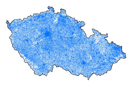
Statistical units - polygons


Basic characteristics
Name: Statistical unit - polygon (POLY_SO);
Abstract: the layer contains the territorial delimitation of census districts in a state in which were used for the organization of the 2001 Census; census districts were transformated in statistical units in 2005; the map layer is also provided in a modification with the title *multi with associated attributes of the territory;
Reason of creation: territorial preparation of the Population and Housing Census 2001; the register update;
Origin: in 1999 - 2000 manual vectorization against a background of cadastral maps at every scale (decimal, fathom, inset) and of every form (raster, vector); the vector boundaries of cadastral districts from the ZABAGED 1 project (Basic map of the Czech Republic 1 : 10 000) and the revised boundaries of basic settlement units (vectorial processed as well - map precision 1 : 10 000) were used as the initial drawing;
Extent / Completeness: territory of the state / 100 %;
Quality: balanced, topologically treated; see also time-laps metadata SO - polygony 3.2.1.2. since 2001;
Number of simulated elements: 53 392 / 53 392;
Publication information
Data interpretation: until 2005 year 31 census districts are not delimited for side buildings and vertically located census districts (above each other according to floors) within high-rise buildings with more than 180 dwellings within respective building identified with one house number; there might occur a difference between administrative (intentionally used for e.g. the Census) and territorial affiliation (i.e. valid according to the delimitation of cadastral districts) of a census district with basic settlement unit, cadastral district, municipality and district (NUTS 4) according to overlaps of municipality parts into a territory of other municipality or cadastral district; because of overlaps there are created such code and name items of these territorial units with the _P feature within the attribute structure, which territorially categorize a statistical district; items without this feature categorize a census district according to the administrative categorization;
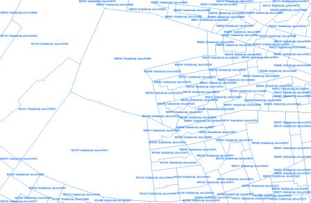
Example: there was untypically delimited the statistical unit 9998 in the Tábor district - this CD is registered in this district, but it is territorially situated in the Písek district; the reason was the municipality part Číčovice situated in the Písek district, but registered in the municipality 549631 Nadějkov within the Tábor district (see the situation map); during 2017 it was settled in favor of Nadějkov municipality, district Tábor;
Export and distribution formats: ArcView Shapefile, ArcInfo Coverage, ESRI Geodatabase (mdb);
Distribution units: arbitrary part of database according to the attribute or spatial selection;
Data source: Czech Statistical Office;
Commencement date: November 2002;
Effective date: 1 January 2020;
Last update: as per 10 January 2020;
Data statute: preparatory;
Legend: color (RGB) 0, 112, 255 - blue line;
Note: -
Preview:
 ►►
►►
Metadata
Metadata author: Ing. Zdeňka Udržalová;
Commencement date: January 2003;
Last metadata update: 3 June 2020;
Spatial scheme
Element type: surface;
Element count: 53 392 (see Data interpretation);
Geometric model: lines / polygons; continuous plane graph;
Topology: yes (planar);
Spatial reference system
Projection coordinate system: S-JTSK_Krovak_East_North;
Geographic coordinate system: GCS_S_JTSK;
Accuracy
Positional: 0,5 - 5 m (map 1 : 1000 - 1 : 10 000);
Logical: definition points of buildings, polygons of statistical units;
Attribute scheme
The list of items:
IDSO ... unique identifier of a statistical (very small) unit (SO) within the CR (dial 0055);
PRES_LAU1 ... "A" = Yes, graphically recorded temporary overlap of buildings / parts of municipality in the territory of another district (different content of KOD / NAZ_LAU1_P and KOD / NAZ_LAU1);
PRES_ORP ... "A" = Yes, graphically recorded temporary overlap of buildings / parts of municipality in the territory of another one (different content of KOD/NAZ_ORP_P and KOD/NAZ_ORP);
PRES_POU ... "A" = Yes, graphically recorded temporary overlap of buildings / parts of municipality in the territory of another one (different content of KOD/NAZ_POU_P and KOD/NAZ_POU);
PRES_OBEC ... "A" = Yes, graphically recorded temporary overlap of buildings / parts of municipality in the territory of another one (different content of KOD/NAZ_OBEC_P and KOD/NAZ_OBEC);
PRES_UTJ ... "A" = Yes, graphically recorded temporary overlap of buildings / parts of municipality in the territory of another one (different content of KOD/NAZ_UTJ_P and KOD/NAZ_UTJ);
PRES_KU ... "A" = Yes, graphically recorded temporary overlap of buildings / parts of municipality in the territory of another one (different content of KOD/NAZ_KU_P and KOD/NAZ_KU);
PRES_ZSJ ... "A" = Yes, graphically recorded temporary overlap of buildings / parts of municipality in the territory of another one (different content of KOD/NAZ_ZSJ_P and KOD/NAZ_ZSJ);
KOD_ORP_P ... municipality with extended competence code (dial 0065);
NAZ_ORP_P ... municipality with extended competence name (dial 0065);
KOD_POU_P ... municipality with authorised municipal office code (dial 0061);
NAZ_POU_P ... municipality with authorised municipal office name (dial 0061);
KOD_OBEC_P ... municipality code (dial 0043);
NAZ_OBEC_P ... municipality name (dial 0043);
KOD_KU_P ... cadastral district code (dial 0063);
NAZ_KU_P ... cadastral district name (dial 0063);
KOD_UTJ_P ... territorial technical unit code (dial 0052);
NAZ_UTJ_P ... territorial technical unit name (dial 0052);
KOD_ZSJ_P ... basic settlement unit code (dial 0047);
NAZ_ZSJ_P ... basic settlement unit name (dial 0047);
LAU1_P ... district LAU 1 code (dial 0109);
SO ... statistical (very small) unit serial number within the district (attribute code 21, dial 0055);
SO_P ... census district original number (before SLDB 2001) (attribute code 544, cis 0055);
NAZ_SO ... statistical (very small) unit name (dial 0055);
KOD_ZSJ_D ... code of a basic settlement unit (segment) (dial 0053);
NAZ_ZSJ_D ... name of a basic settlement unit (segment) (dial 0053);
KOD_ZSJ ... code of a basic settlement unit (dial 0047);
NAZ_ZSJ ... name of a basic settlement unit (dial 0047);
PORCUO ... urbanistic district serial number within the municipality (attribute code 548, dial 0047);
KOD_UTJ ... territorial technical unit code (dial 0052);
NAZ_UTJ ... territorial technical unit name (dial 0052);
KOD_KU ... cadastral district code (dial 0063);
NAZ_KU ... cadastral district name (dial 0063);
PORCIS_KU ... cadastral district serial number within the district (attribute code 28, dial 0063);
KOD_CAST_D ... code of a part of municipality (segment) (dial 0060);
NAZ_CAST_D ... name of a part of municipality (segment) (dial 0060);
PORCCOB ... municipality part serial number within the municipality (attribute code 23, dial 0060);
KOD_ZUJ ... basic territorial unit code (dial 0051);
NAZ_ZUJ ... basic territorial unit name (dial 0051);
KOD_MCO ... city district/borough code (dial 0044);
KOD_UZOHMP ... code of the city district of Prague (dial 0049);
NAZ_UZOHMP ... name of the city district of Prague (dial 0049);
MOBVOD_RUIAN ... code of the city district of Prague from the basic register RÚIAN (attribute code 630, dial 0049);
KOD_SOP ... code of an administrative district of the City of Prague (dial 0072);
NAZ_SOP ... name of an administrative district of the City of Prague (dial 0072);
SOP_RUIAN ... code of an administrative district of the City of Prague from the basic register RÚIAN (attribute code 538, dial 0072);
KOD_OBEC ... municipality code (dial 0043);
NAZ_OBEC ... municipality name (dial 0043);
TYPOBCE ... type of municipality (code 32 link to dial 0067);
PC_OBEC ... municipality serial number within the district (attribute code 649, cis 0043);
KOD_STATM ... code of a statutory city and the Prague (dial 0069);
NAZ_STATM ... name of a statutory city and the Prague (dial 0069);
KOD_POU ... municipality with authorised municipal office code (dial 0061);
NAZ_POU ... municipality with authorised municipal office name (dial 0061);
POU_RUIAN ... municipality with authorised municipal office code from the basic register RÚIAN (attribute code 537, cis 0061);
KOD_ORP ... municipality with extended competence code (dial 0065);
NAZ_ORP ... municipality with extended competence name (dial 0065);
ORP_RUIAN ... municipality with extended competence code from the basic register RÚIAN (attribute code 536, dial 0065);
KOD_OKRES ... district code (dial 0101);
NAZ_OKRES ... district name (dial 0101);
LAU1 ... district code LAU 1 (dial 0109);
CZNUTS4 ... district code of level NUTS 4 Classification of Territorial Statistical Units CZ-NUTS (dial 0109) - from 1.1.2008 empty;
KOKRES_RUIAN ... district code from the basic register RÚIAN (attribute code 535, dial 0045);
KRAJ_1960 ... region code by Act No. 36/1961 Coll. (attribute code 500, dial 0101);
KOD_KRAJ ... region code (dial 0100);
NAZ_KRAJ ... region name (dial 0100);
NUTS3_KRAJ ... region code NUTS 3 Classification of Territorial Statistical Units CZ-NUTS (attribute code 42, dial 0100);
KKRAJ_RUIAN ... region code from the basic register RÚIAN (attribute code 534, dial 0100);
KOD_REGS ... cohesion region code (dial 0099);
NAZ_REGS ... cohesion region name (dial 0099);
NUTS2_REGS ... code NUTS 2 Classification of Territorial Statistical Units CZ-NUTS (attribute code 41, dial 0099);
KREGS_RUIAN ... cohesion region code from the basic register RÚIAN (attribute code 533, dial 0099);
KOD_UZEMI ... territory NUTS1 code (dial 0098);
NAZ_UZEMI ... territory NUTS1 name (dial 0098);
NUTS1_UZEM ... code NUTS 1 Classification of Territorial Statistical Units CZ-NUTS (attribute code 40, dial 0098);
KOD_STAT ... code of the state (dial 0097);
NAZ_STAT ... name of the state (dial 0097);
NUTS0_STAT ... code NUTS 0 Classification of Territorial Statistical Units CZ-NUTS (attribute code 39, dial 0097);
KSTAT_RUIAN ... code of the state from the basic register RÚIAN (attribute code 532, dial 0097);
KOD_MU ... registration office code (dial 0045);
NAZ_MU ... registration office name (dial 0045);
KOD_FU ... revenue office code (dial 0046);
NAZ_FU ... revenue office name (dial 0046);
KOD_SU_ZJ ... building office code (dial 1183);
NAZ_SU_ZJ ... building office name (dial 1183);
PSC ... address post office postcode (dial 0028);
NAZ_POSTA ... mail delivery name (dial 0028);
SOJTSK_X ... X coordinate of statistical unit definition point in the JTSK system (attribute code 60168, dial 0055);
SOJTSK_Y ... Y coordinate of statistical unit definition point in the JTSK system (attribute code 60168, dial 0055);
VYMERA ... area of statistical unit in square meters (attribute code 60170, dial 0055);
PLATIOD ... beginning of the time validity of SO (date) (dial 0055);
NEPLATIPO ... end of the time validity of SO (date) (dial 0055);
Multi1/ layer also contains other SO attributes:
DOMINPSC ... dominant postcode of buildings in the SO (attritute code 60012, dial 0055);
POCADR ... number of addresses (attribute code 60164, dial 0055);
POCBUD ... number of buildings (attribute code 60160, dial 0055);
POCBUDBYT ... number of residential buildings (attribute code 60161, dial 0055);
POCBUDKRUB ... short-stay accommodation buildings (attribute code 60163, dial 0055);
PBUDCP ... number of buildings with house number (attribute code 60176, dial 0055);
POCBYT ... number of dwellings (attribute code 60014, dial 0055);
POCBYTOB ... number of dwelling unites inhabited (attribute code 60015, dial 0055);
POCOBYEV ... number of residents in the buldings (attribute code 60172, dial 0055);
POCOIR ... number of objects of individual recreation (attribute code 60162, dial 0055);
POCOBYSL01 ... number of residents in the buldings by Census 2001 (attribute code 60165, dial 0055);
POBYOSL11 ... number of residents in the buldings by Census 2011 - habitual residence (attribute code 60173, dial 0055);
POCOBYSL11 ...number of residents in the buldings by Census 2011 - permanent residence (attribute code 60166, dial 0055);
PRESAH ... overlap of buildings to territory of other municipality (attribute code 60167, dial 0055);
1/ one territorial unit in a map corresponds to one sentence in the attached database (see also Methodology of support for the display of discontinuous territorial units in the GIS)
Language / character set: czech / win1250;


